
![]()
![]()
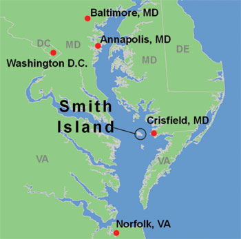
From the North via Wilmington:
- Follow I 95 South from Wilmington to exit 4A towards
Christiana, DE.
Go south on 1, 301 and 13 towards Dover. - Approaching Dover, take 1 which will bypass business Dover and reconnects to 13 South.
- Follow 13 South towards Salisbury.
- Take the 13 by-pass around Salisbury following sign for Route 50 East towards Ocean City and US 13. Stay on this bypass and do not exit for any further Route 50 signs or for business 13. The bypass will end on Route 13 heading south towards Princess Anne.
- Continue on 13 through Princess Anne and after approximately 5 miles watch for Route 413 on the right towards Crisfield. It is well marked. Take 413 to the end. Ferries to Smith Island are at the dock at the end of 413.
From Baltimore:
- 295 South from Baltimore to 695 East and I 97 South towards
Annapolis.
Follow I 97 to Annapolis. - Near Annapolis, take Route 50 East. After the Bay Bridge and Kent Island Bridge, bear right at Y and continue on Route 50 East.
- Take Route 50 through Easton and Cambridge. Shortly before
Salisbury, take the Salisbury by-pass, following sign for 50 East
and 13
towards Ocean City. - Stay on this road and do not exit for any further route 50 signs or for business 13. The by-pass will end on Route 13 heading south towards Princess Anne.
- Continue on 13 through Princess Anne and after approximately 5 miles watch for Route 413 on the right towards Crisfield. It is well marked. Take 413 to the end. Ferries to Smith Island are at the dock at the end of 413.
From the West:
-
Route 50 East towards Annapolis and Bay Bridge. Then follow the Baltimore directions above from Annapolis.
From the South via Norfolk:
- Bridge-Tunnel North from Norfolk area to Eastern Shore of
Virginia.
Take Route 13 North, passed Pocomoke City. Approximately 8 miles after Pocomoke City, watch for Route 413 on the left and take it East/South towards, Crisfield. - Take 413 to end. Ferries to Smith Island are at the dock at the end of 413.
Please check internet mapping services for detailed directions
and distances from your location.